
Historic Floods
Introduction
Over the past 100 years, significant floods have occurred along the Assiniboine and Souris Rivers with the largest flood occurring in 2011. Since records began there have been at least six major floods on the Assiniboine River, the most recent in 1976, 1995, 2011 and 2014.

During a typical flood season, a portion of the Assiniboine River’s flood waters are stored in the Shellmouth Reservoir and a portion of it is diverted from the Assiniboine River to Lake Manitoba through the Portage Diversion. The operation of these hydraulic structures is for the flood protection of downstream communities along the Assiniboine River and the City of Winnipeg and, therefore, the structures are operated in conjunction with the Red River Floodway. On Lake Manitoba, the Fairford River Water Control Structure is operated to regulate the water levels of Lake Manitoba and offsets the increased volume of water entering the Lake from the Portage Diversion.

The Assiniboine River and Lake Manitoba basins
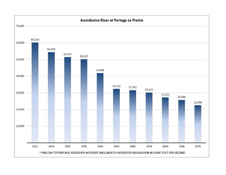
Top 10 Assiniboine River Floods Since 1880s
Historic Flood Events
1882
The flood of 1882 occurred before there were any recorded measurements of stream flow or lake levels in Manitoba. However, descriptions of the flood are documented in numerous sources. Overflows from Lake Manitoba and the Assiniboine River caused impacts to railway infrastructure and agricultural settlements. The extents of the damages from the flood were significant enough that the Manitoba Legislative Assembly struck a committee in 1884 to study the 1882 overflow of the Assiniboine River and Lake Manitoba. According to reports, the water in the Assiniboine River was so high that it overflowed into Lake Manitoba. And then conversely, later on in the flood, Lake Manitoba was so high that water from Lake Manitoba overflowed into Long Lake eventually making its way back to the Assiniboine River.
In 1952, the peak flows for the 1882 flood were estimated by the Prairie Farm Rehabilitation Administration. The 1882 peak flows in the Assiniboine River were estimated to be 1,218 cms (43,000 cfs) at Brandon and 906 cms (32,000 cfs) at Headingley.
More information on the flood of 1882 can be found in the report produced by the Province of Manitoba titled: “2011 Flood: Technical Review of Lake Manitoba, Lake St. Martin, and Assiniboine River Water Levels (October 2013)” (ZIP, 14 MB)
1976
The flood of 1976 was the largest flood on the Assiniboine River since the flood of 1882. The flood developed due to high soil moisture conditions going into the fall of 1975, higher than normal snowpack in the Souris River Basin (300 to 400 percent of normal) and the Assiniboine River Basin (200 to 300 percent of normal), and a very rapid snowmelt.
The flow along the Assiniboine River just upstream of Portage La Prairie peaked at 1,388 cms (49,000 cfs) in 1976. At peak discharge the Portage Diversion was used above its maximum design capacity to divert 736 cms (26,000 cfs) to Lake Manitoba. The Lower Assiniboine River dikes extending from Portage La Prairie to east of Baie St. Paul were reinforced to prevent major overland flooding. A peak flow of 668 cms (23,600 cfs) was recorded in the Assiniboine River at the Southport bridge on April 21st. Plywood flashboard was installed along the top of the dikes, in order to contain the high flows at the peak for a brief period of time. Flows above 510 cms (18,000 cfs) in the Lower Assiniboine lasted for about one week.
The volume of water discharged into Lake Manitoba from the Portage Diversion in 1976 was 1,750,000 cubic decametres (1,420,000 acre-feet). This makes up 39% of the total annual inflow volume of water into Lake Manitoba in 1976.
 |
 |
| Overland flooding along the Lower Assiniboine River | Overland flooding along the Lower Assiniboine River |
 |
 |
| Poplar Point Bridge | Reinforcing Assiniboine River Dikes |
 |
 |
| Preparing Sandbags | Flash Boarding along Assiniboine River Dikes |
1995
The flood of 1995 was one of the most significant floods in recent years. Heavy rains in the summer and fall of 1994 and the resultant saturated soils were the preconditions that contributed to spring flooding. The recorded peak flow in the Assiniboine River in Kamsack, Saskatchewan was nearly twice as high as the previous record peak flows, which occurred in 1976. The peak flow of water upstream of the Portage Diversion was 711 cms (25,100 cfs). A peak flow of 390 cms (13,800 cfs) was diverted down the Portage Diversion channel. The Portage Diversion contributed 1,380,000 cubic decametres (1,115,000 acre-feet) of water to Lake Manitoba in 1995; which made up for 41% of the annual volume of water inflow into Lake Manitoba.
2011
To date, the 2011 flood represents the largest flood of record for the Assiniboine River. The flood was caused by the following factors: above normal soil moisture at freeze-up (130% above normal), above normal winter snow pack (150% above normal), and above normal spring precipitation (200-300% above normal). Major storms in May and June within the Souris River Basin caused high flows and multiple peaks on the Souris River. A total of 16 hydrometric gauging stations reported record peak flows or water levels during the 2011 summer flood event.
Planning and preparation for the flood of 2011 began in November of 2010 when the unprecedented high flows on the Assiniboine River were two times greater than those in 1975, leading up to the flood 1976.
In mid-May, Provincial staff forecasted a peak flow of 1585 cms (56,000 cfs) on the Assiniboine River upstream of Portage La Prairie for unfavourable future weather conditions. This peak flow was well in excess of the maximum safe capacity of the Assiniboine River channel downstream of the Portage Diversion (510 cms (18,000 cfs)) plus the design capacity of the Portage Diversion (708 cms (25,000 cfs)).
In response to the forecasted flows, work was undertaken to increase the capacity of the Portage Diversion to approximately 960 cms (34,000 cfs). These works included fortifying the dikes, re-enforcing the channel drop structure walls, placing rip-rap around bridge crossings including rail bridge crossings and raising the levels of the dikes.
A contingency plan also had to be developed to handle any flow in excess of sum of the maximum capacity of the Assiniboine River dikes and the temporarily upgraded Portage Diversion. The selected plan involved a controlled breach of the Assiniboine River dikes at the Hoop and Holler bend. A controlled release at this point meant that anticipated excess flow could be diverted safely away from the Assiniboine River, southeast towards the Elm River which then flows east into the La Salle watershed/River and then empties into the Red River south of Winnipeg.
The maximum recorded daily inflow into the Portage Reservoir ended up being 1,504 cms (53,100 cfs) on May 14. The maximum recorded daily flow in the Portage Diversion was 983 cms (34,700 cfs). Flow through the controlled breach at the Hoop and Holler cut was maintained between 5.66 cms (200 cfs) and 11.3 cms (400 cfs). A total of 3.4 square kilometers (1.3 square miles) were inundated by floodwaters flowing through the controlled release.
")
Map of Diverted Flows from the Hoop and Holler Controlled Release Site, May 19, 2011 that affected 3.42 square kilometres. (Source: Manitoba Infrastructure)
In 2011, the Portage Diversion contributed a total of 5,870,000 cubic decametres (4,762,000 acre-feet) of water into Lake Manitoba. This contribution was the largest volume of water contributed to the lake by the Portage Diversion in the diversion’s history. As 2011 was also a year of unprecedented flooding in the Lake Manitoba Basin, this record contribution for the Portage Diversion resulted in 38% of the annual volume of water inflowing into the lake.

 |
 |
| Major reinforcement of lower Assiniboine River dikes in early 2011 | Hoop and Holler Cut, May 2011 |
 |
 |
| Assiniboine River and Portage Diversion at Southport, May 2011 | Portage Diversion at first drop structure, May 2011 |
 |
 |
| Portage Diversion dike maintenance, May 2011 | Portage Diversion second drop structure maintenance, May 2011 |
 |
 |
| Helicopters deliver sandbags to Assiniboine River dike reinforcement. May 2011 | Overland Flooding, Assiniboine River north of St. Eustache, May 2011 |
 |
 |
| Long Lake Drain at Assiniboine River, May 2011 | Lower Assiniboine, Overland Flooding, May 2011 |
 |
 |
| Portage Diversion dike failure, May 2011 | Portage Diversion, 3 km upstream of Lake Manitoba, May 2011 |
 |
 |
| Assiniboine River at P.R. 240, May 2011 | St. Francois Xavier May 2011 |
 |
 |
| Assiniboine River, 9 km East of Poplar Point, May 2011 | Caron Drive, St. Francois Xavier, May 2011 |
 |
 |
| Assiniboine River at Headingley, May 2011 | P.R. 26 Adjacent to Assiniboine River, May 2011 |
2014
In the summer of 2014, exceptionally heavy rains in the Upper Assiniboine Basin caused major flooding on the Assiniboine River. The unregulated peak flow at Brandon was the 2nd highest in recorded history, occurring only 3 years later than the record setting flood of 2011.
The summer flooding experienced in 2014 can be attributed to the amount of precipitation that occurred in the last four days of June as well as the accumulated precipitation that occurred during April, May and June.The earliest forecast for the summer 2014 event suggested that flows on the Assiniboine River upstream of the diversion would be between 1,360 cms (48,000) to 1,472 cms (52,000 cfs), but these were later revised to between 1,472 cms to 1,530 cms (52,000 to 54,000 cfs). This is similar to the 2011 event which saw peak flows of approximately 1,504 cms (53,100 cfs).
In response, the Province issued a Provincial State of Local Emergency on July 4th and on July 5th requested additional support from the Canadian Armed Forces to assist in flood protection preparations along the Assiniboine River. In a very short amount of time, Manitoba Infrastructure personnel worked with contractors and engineering service providers to undertake the following works along the Portage Diversion and along the lower Assiniboine River:
- Inspection, preparation and monitoring of the diversion channel dikes and related infrastructure for increased flows of 963 cms (34,000 cfs),
- Inspection, preparation and monitoring of the Assiniboine River dikes to handle flows of 510 cms (18,000 cfs),
- Preparation of the Hoop and Holler controlled breach site on the Lower Assiniboine River to alleviate flows above 510 cms (18,000 cfs) if required,
- Coordination of temporary flood protection efforts along the lower Assiniboine River beyond the Provincial Dikes to protect approximately 136 homes at risk of flooding.
The 2014 summer flood had two distinct flood peaks within a week of each other at Portage La Prairie. The first peak reached Portage la Prairie on July 9th with an estimated instantaneous peak inflow to the Portage Reservoir of 1,442 cms (50,050 cfs). Of that, 928 cms (32,800 cfs) was sent down the Portage Diversion, with the remaining 514 cms (18,150 cfs) allowed to flow through the bascule gates to the Lower Assiniboine river. On July 15th, a second crest arrived at Portage la Prairie with an estimated instantaneous peak inflow to the Portage Reservoir of 1,458 cms (51,500 cfs). Of that, 948 cms (33,500 cfs) was sent down the Portage Diversion, with the remaining 510 cms (18,010 cfs) allowed to flow through the bascule gates to the Lower Assiniboine River. The summer operation of the Portage Diversion lasted approximately 60 days (June 30 – August 28).
The flow volume diverted to Lake Manitoba was the second largest diverted volume since construction of the Portage Diversion. In 2014, the diversion contributed 2,720,000 cubic decametres (2,206,000 acre-feet) of water to Lake Manitoba, representing 24% of the annual inflow volume to the lake.

 |
 |
| Portage la Prairie Operations Centre, 2014 | Assiniboine River at P.R. 248, July 2014 |
 |
 |
| Portage Diversion at Highway 1, July 2014 | Portage Diversion Controlled Breach, July 2014 |
 |
 |
| Overland Flooding, St. Francois Xavier, July 2014 | Assiniboine River Control Structure |