
Assiniboine River Dikes
Background and Description
The lower Assiniboine River from approximately Portage la Prairie downstream, as well as the region around the river, are particularly vulnerable to flooding due to a limited natural channel capacity of the river and the flat topography that would allow any overflows from the Assiniboine River to spread and inundate large areas of the relatively flat prairie. As the river had a limited natural channel capacity in this stretch, generally estimated at between 8,000 to 15,000 cfs, the dikes effectively increase the capacity of the Assiniboine River. The increased capacity provided by the Assiniboine River dikes, which, along with the Shellmouth Dam and Reservoir and the Portage Diversion, prevents overflows from the river and offers flood protection a number of communities adjacent to the river, such as Portage la Prairie, Elie, and St. Francois Xavier, as well as communities to the south including La Salle, Sanford and Starbuck. A significant amount of agricultural land is also protected from inundation as an incidental benefit.
The Assiniboine River dike system consists of continuous dikes on both the north and south sides of the river, starting near Portage la Prairie running along the river to a short distance downstream of Baie St. Paul. The length of the dikes is approximately 72 km (45 miles) on the north side of the river and 78 km (49 miles) on the south side of the river. The dikes were generally constructed of local materials and, as the soils in the area tend to be relatively sandy, this has contributed to challenges in maintaining the dikes and in ensuring that they can operate safely for extended durations.
The Assiniboine River dikes were not built as a single project that was completed at one point in time, instead the dikes were built over a number of decades by a combination of different governments and private landowners. Early settlers began building dikes to protect their homes and farmland as far back as the late 19th century. The federal government initially became involved in the construction of the dikes in 1913, through the department of Public Works. Construction records indicate that the dikes had not been built to a consistent flood protection level or engineering design standard, but instead, were often built to local high water marks and with varying widths and side slopes. A large number of dikes were built on private land and in some cases access to the dikes was not secured through federal land ownership or easement agreements. Ownership of the dikes was transferred to the Prairie Farm Rehabilitation Administration (PFRA) in 1950. Works to raise and reinforce the dikes to provide a consistent flow capacity of 22,500 cubic feet per second (cfs) were completed in 1967. In 1996, the federal government turned ownership and maintenance responsibility for the Assiniboine River dikes over to the provincial government.
Dikes have also been constructed along the Assiniboine River downstream (to the east) of the provincial dikes. These dikes are not provincial infrastructure but instead are privately owned. Many were built by the federal government; however, ownership and maintenance was left to the individual landowners and municipalities. The reason for this difference in ownership is due to the private flood protection benefits provided by the dikes. Ownership remains varied between private and municipal ownership as flooding in this region is generally local in nature whereas flooding in the vicinity of the provincial dikes is likely to have impacts in a much larger area.
Geography of the Lower Assiniboine River and Need for the Dikes
The Assiniboine River rises in eastern Saskatchewan on the upper prairie level above the Manitoba Escarpment. Within Manitoba, the Assiniboine River flows through three distinct zones, each with very different channel characteristics. Upstream of Brandon, the main stem of the river and its most important tributaries flow within a very large valley (spillway) cut by glacial meltwater in the late stages of the last glaciation; the floor of this spillway valley provides a natural floodplain for the river and the valley provides a significant storage volume. This feature of the valley made the construction of the Shellmouth Dam near Russell both technically and economically viable. In this zone of the Assiniboine River, the major tributaries are the Qu’Appelle, Shell, and Little Saskatchewan Rivers.
Between Brandon and Portage la Prairie, the river has eroded downward through sediments of the glacial “Assiniboine Delta”, a large delta formed where a glacial meltwater channel emptied into Glacial Lake Agassiz. The head of this delta was approximately at Brandon and its furthest eastern extent was just west of Portage la Prairie (reference Figure 1 - the delta is visible as the dark grey area, labelled “Glaciofluvial Sediment”, between Brandon and Portage la Prairie). The Assiniboine River has cut a narrow valley through these sediments as it drops through a vertical distance of approximately 150 metres (492 feet) to the Lake Agassiz/Red River Plain. In this valley, the river is highly confined with a narrow valley floor. The Souris River is the primary tributary contributing flow to the Assiniboine in this reach.
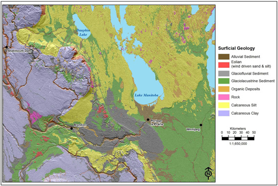
Figure 1: Surficial geology of Manitoba. The Assiniboine delta is visible as glaciofluvial sediment in dark gray between Brandon and Portage la Prairie, and the alluvial fan is visible in brown stretching to the north and east of Portage la Prairie.
Near Portage la Prairie, the river emerges from the confinement of the delta reach onto the relatively flat Lake Agassiz/Red River Plain (the floor of former Glacial Lake Agassiz) and at this point it can flow in any direction within an arc of about 180? from roughly north-west to roughly south-east (reference Figure 2). The slope of the river channel within the delta reach to the west is relatively high, so the river water velocities are relatively high and the waters of the river carry significant amounts of sediment. However, the slope of the land in the flat Lake Agassiz/Red River Plain is much less, and so the velocity of the river water flowing over this Plain is much lower. At slower speeds, the sediment-carrying capacity of the river waters as they flow over the Plain is greatly reduced, and the sediments carried by the river waters as they flow through the delta reach are deposited onto the Plain.
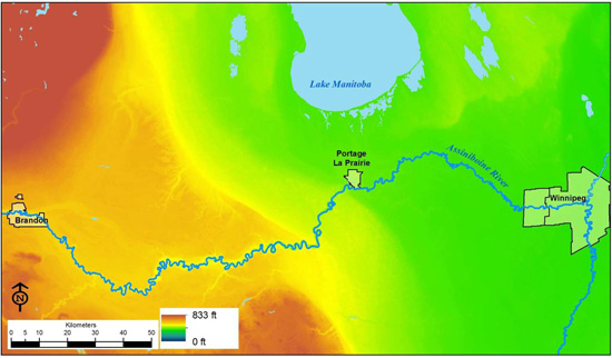
Figure 2: Land surface elevations of south-central Manitoba.
The deposition of sediment in this reach of the river results in the river building its channel into an "alluvial ridge". The alluvial ridge is built from sediments deposited along the channel as levees and within the channel itself, a process which gradually elevates the channel above the adjacent terrain until the river is flowing along a "ridge" (rather than in a depression at the lowest elevations, which is the norm) (reference Figure 3). It may be useful to visualize the alluvial ridge like a ramp that the river has built through deposition as it descends to the Lake Agassiz plain. In those portions of the alluvial ridge where the bed of the Assiniboine River (i.e. bottom of the river channel) is actually at a higher elevation than the surrounding prairie, it is sometimes referred to as a "perched river." This is an inherently unstable situation and if the natural levee is breached for some reason (perhaps during a large flood, bank collapse, ice jam, etc.), the flow will escape into the lower surrounding area and the channel downstream of the breach will be abandoned, usually permanently, in favour of another route through the lower terrain (reference Figure 4). This process of sudden abandonment is called "avulsion". Each avulsion is followed by the build-up of sediments along the new channel until it too has formed an alluvial ridge, which eventually leads to another avulsion episode.
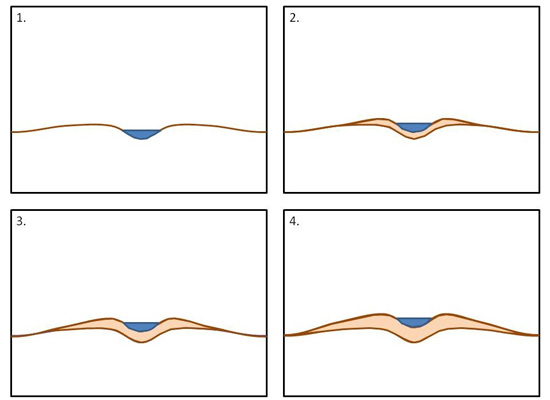
Figure 3: Formation of an alluvial ridge. Note that deposition builds up natural levees on each side of the stream as well as in the bed of the stream.
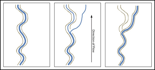
Figure 4: Sequence of events leading to avulsion on the alluvial fan. The top of the natural levees on the alluvial ridge are shown as the brown line next to the river.
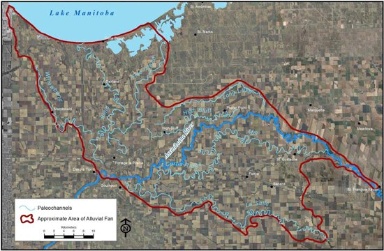
Figure 5: The alluvial fan and location of paleochannels in the lower Assiniboine River.
The repeated formation and abandonment of alluvial ridges has produced an "alluvial fan" which radiates outwards from its apex southwest of Portage la Prairie at the point where the river leaves the Assiniboine Delta and enters the Lake Agassiz/Red River Plain. The alluvial fan is an accumulation of sediment deposited by the river. The fan is thickest (that is highest) near Portage la Prairie and thins outward (down-fan) to the north, east and south. The extent of the alluvial fan along with many of the channels that formed the fan can be seen in Figure 5 above, and the alluvial fan is also visible as the brown area north and east of Portage la Prairie in Figure 1.
Near the fan apex, the alluvial fan is a broad dome of sediment. Progressively further downstream, the individual alluvial ridges become more distinct and the fan consists of finger-like ridges separated by lower zones where the Lake Agassiz clay plain "shows through" (reference Figure 6). Eventually the alluvial fan ends, beyond about 20 to 35 km (12-22 miles). From this point eastward, the topographic relationship between the river channel and the surrounding terrain is inverted into a more normal situation where the river channel is cut into the Lake Agassiz clays as a depression which deepens as it approaches its junction with the Red River. A generalized profile of the Assiniboine River between Brandon and Winnipeg is shown in Figure 7.
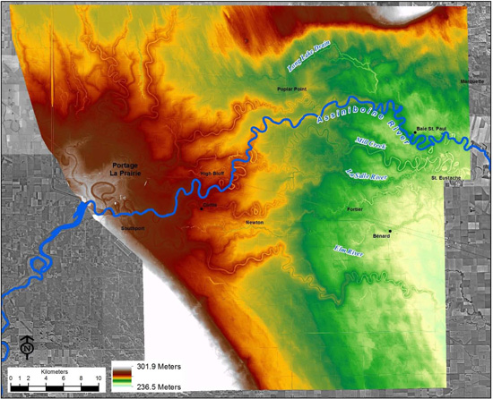
Figure 6: Land surface elevations of the Assiniboine River alluvial fan generated from LiDAR data.
Many of the paleochannels are visible, along with the adjacent higher land formed by sediment deposition.
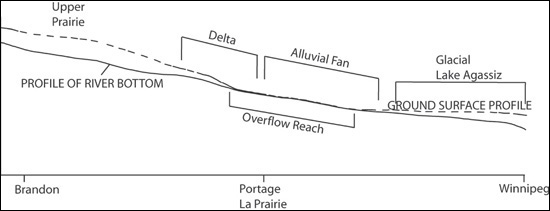
Figure 7: Generalized profile of the Assiniboine River to illustrate the topography and the major features,
such as the Assiniboine Delta and the alluvial fan that the Assiniboine River crosses between Brandon and Winnipeg.
The abandoned paleochannels on the alluvial fan are often indistinguishable on the ground having been in-filled by centuries of sedimentation during floods. However, they are strikingly clear from the air (reference Figure 8). Some of the paleochannels are now used by smaller streams; for example, the present LaSalle River flows eastward through a paleochannel of the Assiniboine River to join the Red River at St. Norbert.
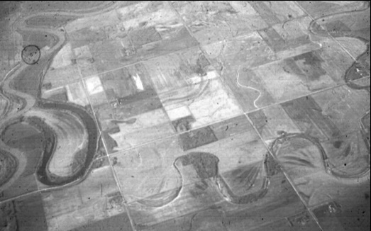
Figure 8: Air photo showing the Assiniboine River on the left edge of the photo and Mill Creek paleochannel. North is oriented towards the top of the photo (Photo courtesy of Dr. Bill Rannie).
The evolution of these paleochannels over the past 7,000 years is shown schematically in Figure 9. The paleochannels divide into two groups: those which end in Lake Manitoba (Willowbend, Blind/Fort la Reine, Flee Island) and those which ultimately end in the Red River (current Assiniboine, LaSalle, Long Lake/High Bluff).
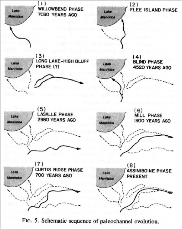
Figure 9: Sequence of paleochannel evolution of the Assiniboine River
(Rannie, Thorleifson, & Teller, 1989)? 2008 Canadian Science Publishing or its licensors. Reproduced with permission.
The alluvial fan/paleochannel complex has several consequences for flow during the largest floods on the Assiniboine River. During large flood events, flows cannot be contained within the existing river channel and so flow overland and by paleochannels over the alluvial fan.
- Under unregulated conditions most overbank flow during large floods spreads away from the river and much of this flow may not return to the main river channel.
- Some of the overbank flow will travel overland away from the river but a potentially large amount will follow one or more of the paleochannels.
- The paleochannels which flow to Lake Manitoba have the potential to convey some floodwater to the lake.
- Some of the overflow to the north could travel eastward via the Long Lake channel to ultimately rejoin the Assiniboine River further down the fan.
- Overflow to the south would either follow the La Salle Channel to join the Red River in south Winnipeg (inside the Floodway West Dike), or re-enter the main Assiniboine River channel further down the fan, perhaps along the Curtis Ridge/Mill Creek paleochannels.
It is also important to note that the present Assiniboine River channel is potentially unstable during the largest floods. In such large floods the natural ridges/levees or man-made dikes would be breached. In such a situation, there is the potential for a new avulsion to occur which could cause the river to relocate to a lower but unpredictable position.
Overflows from the Assiniboine River
Based on information from historic records, Figure 10 below provides a general overview of the pattern that overflows from the Assiniboine River would be expected to follow; the blue arrows represent the flows in the present Assiniboine River Channel, while the green arrows represent overflows in paleochannels or across the prairie. In general, overflows on the north side of the river would be expected from the vicinity of Portage la Prairie to approximately Baie St. Paul (reference Figure 6 for location of High Bluff and Baie St. Paul), with a portion of the flows rejoining the Assiniboine River main channel; to the south a large portion of the overflows would flow into the La Salle River watershed, a portion of the flows would make their way back into the Assiniboine River in the vicinity of St. Francois Xavier, and a portion of the flows would follow the La Salle River to join the Red River upstream of Winnipeg; a portion of the flows would be stored on the floodplain, either in depressions or in the soil; and a portion of the overflows would have flowed north to Lake Manitoba via some of the old paleochannels.
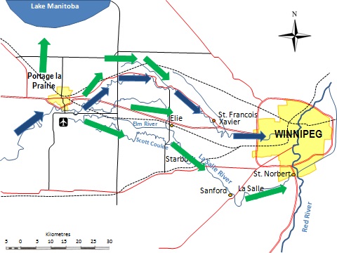
Figure 10: Schematic showing expected distribution of flows and
overflows under unregulated conditions at the 2011 peak.
Operational Information
- Links to real-time data (Water Survey of Canada real-time gauges)